Sunday, July 26, 2026
News and Views from the Global South
CLIMATE CHANGE: ‘High Glaciers Safe From Warming’
Christopher Pala
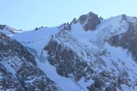
High glaciers such as this one in the Tian Shan mountains in Kazakhstan are said to be safe from global warming. Credit: Christopher Pala/IPS.
- Global warming will melt far less of the glaciers of Central Asia than of those in other mountain ranges, shielding the people who depend on them for water from the effects of climate change for several decades at least, scientists say.
High glaciers such as this one in the Tian Shan mountains in Kazakhstan are said to be safe from global warming. Credit: Christopher Pala/IPS.
“It doesn’t make much difference if it gets a little warmer up there because it’s still far below zero.”
Glaciers are rivers of ice fed by snowfall at the top. As they flow downhill to warmer temperatures, they eventually melt, providing water in summer, when rainfall is usually lowest.
Since the end of the two-centuries-long Little Ice Age in 1850, the terminus point of most glaciers has been slowly retreating uphill. That retreat accelerated since gases like carbon dioxide emitted by coal burning and cars have been accumulating in the atmosphere, creating a greenhouse effect that has raised global temperatures on average by half a degree Celsius in the past 30 years.
How much water a glacier produces each year is mostly determined by how much snow falls on their upper part, not at what point they end. So far there is no evidence that less snow is falling on their higher parts or that they produce more or less melt water, according to Armstrong and other scientists.
In the first comprehensive study of a part of what is called High Asia, the scientists found that 96 percent of the water that flows down the mountains of Nepal into nine local river basins comes from snow and rain, and only 4 percent from summer glacier melt. Of that 4 percent, says Armstrong, the lead author, only a minuscule proportion comes from the melting away of the end points of the glaciers due to global warming.
Armstrong said there is a lot of misinformation in the public arena regarding glaciers, including reports that glaciers in the Himalayas are receding faster than anywhere else in the world and that if this rapid melting continues, rivers are on track to first flood and then dry up. “Those reports simply are not true,” says Armstrong.
“There is a lot of international interest in accurate water resource data from the High Asia region and what the water security consequences are, since water conflicts between countries can escalate rapidly,” adds Mark Williams of the same university’s Institute of Arctic and Alpine Research.
Glaciers in other, lower parts of the world melt in summer over their entire course, so if temperature increases, they melt faster. If temperatures keep rising and that loss is not compensated by increased snowfall in winter – and in some of those glaciers it is – the entire glacier will eventually disappear, Armstrong explains. With it, the summer melt water prized by irrigation farmers, households and users of electricity produced by dams could also disappear.
“But High Asia is different because it’s so much higher,” he says, referring to the Himalaya, Pamir, Karakoram, Hindu Kush and Tian Shan ranges that straddle parts of China, Bhutan, Nepal, India, Pakistan, Kyrgyzstan, Tajikistan, Kazakhstan, Uzbekistan and Afghanistan.
“About half of the surface of the glaciers there is above 5,500 metres,” he says, the point at which glaciers never melt. These glaciers include the longest in the world outside of the polar regions, the Fedchenko, which is 77 km long (the longest, the Lambert in Antarctica, is over 400 km long).
While melting ice from glaciers in Antarctica and Greenland is responsible for about two-thirds of the recent rise in ocean levels (the last third is because water takes up more volume when it gets warmer), the runoff from the melting of the lower glaciers of High Asia should not have much effect on ocean levels because little ends up in the oceans, the scientists say.
What does affect the third of the world’s population that depends on water from High Asia is where their water comes from – how much from rain, snow and glacier melting. “At this point we simply don’t know,” says Armstrong.
This month, he traveled to Almaty to meet with other scientists and launch a four-year, 5.4 million dollar programme funded by USAID to provide answers to those questions.
The programme will use 10 years’ worth of satellite and weather data, augmented with local measurements, to determine with unprecedented exactitude across the whole region how much of the water that feeds the great irrigating rivers (the Amu and Syr Darya, the Ganga, Bramaputra and Indus) comes from snowmelt, how much from rain and how much from glaciers.
“This study should provide answers as to what is real and what is false,” says Williams.
Such knowledge is commonly available in the U.S. and Europe. It helps people to plan the allocation of water: for instance, after a winter of light snowfall, knowing a river gets 25 percent of its water from glaciers melting in summer, you can figure out how much water you’ll get that summer. Given that these rivers are major sources of irrigation, this knowledge will be very helpful.
While the retreat of the glaciers is too slow to be discernable with great precision with only ten years worth of data, Armstrong says that knowing how much water comes from summer glacier melt will allow planning for the effects of climate change, such as variations in snowfall and rain and the melting of the low-lying glaciers.
“Once we have a picture of recent and current conditions, we can go forward and run computer ‘melt models’ based on the temperatures at various elevations, giving us trends in snowmelt and glacier melt by region and time,” says Armstrong. “That’s when we start to come up with water volumes for individual rivers and streams from both melting snow and ice.”
 Print
|
Print
|

Pictures for this story
This story includes downloadable print-quality images -- Copyright IPS, to be used exclusively with this story.