Monday, July 27, 2026
News and Views from the Global South
Heaviest Ever Floods in Northern Namibia
- North-central Namibia is experiencing the heaviest floods ever recorded, but unlike in previous years, the area is fully prepared.
Flood levels in the Cuvelai basin in north-central Namibia are eight centimetres higher than in the 2009 flood season, setting a new record for the area where about one million people – half of Namibia’s population – live.
Every year Efundja – the Oshiwambo name for the annual floods coming from Angola – fills the shanas (floodplains) in the northern regions. The arrival of the flood is much anticipated as it brings fish, restores grazing capacity and ensures water reserves for the dry months ahead. But in recent years floods have become heavier and more frequent, generally doing more damage than good.
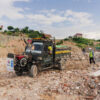
Infrastructure destroyed
“It’s going to be bad,” predicts Guido van Langenhove., Director of Hydrology in the Department of Water in Windhoek. “There have been good rains up in the catchment area in Angola over the past few days. This water will reach us in two weeks time. If, in the meantime it keeps raining in the Namibian part of the catchment, the inundations will get much worse.”
"The situation is terrible," agricultural extension officer Miriam Fikunawa tells IPS by mobile phone from Okalongo village. "There is a lot of water and the flood is much worse than in 2009. All the roads are flooded and you cannot reach this area because it is completely under water.
"The clinic is unreachable and doctors and nurses are visiting patients by helicopter in order to stll give them medical attention.
"All the fields are under water and there hardly is grazing left for animals. Even people's houses are flooded and they are taking to tented camps in higher areas.
"There will be no harvest this year. The plants are hammered by the rains and the grain is scattered all over. This will be a very poor growing season.
"There is not much we can do. We are asking people to come register at the office so we can get an overview of the number of people that are affected and we can inform the central government."
The daily warnings that the hydrology people in Windhoek send out show an overall increase of water levels across the region. “[There were] more good rains in [the] Omusati and Ohangwena regions. The flooding situation in the Cuvelai area in Namibia has got worse than in 2009,”
“Roads and bridges have been washed away and some areas are heavily flooded. Our offices are inundated; you need gumboots to get in,” says Andreas Shilomboleni from the Climate Change Adaptation project in Outapi, close to the Angolan border. “Areas near the main oshana’s communities are isolated and millet fields owned by subsistence farmers are severely affected.”
“It’s very bad,” says Leonard Hango, hydrologist and support officer for the Iishana sub-basin. Hango is based in Oshakati, the largest population centre in northern Namibia. “The Oshakati town council put up an embankment, but the wall broke down and the water has flooded the locations.
“So far 1,200 people have lost their homes and are accommodated in two temporary camps,” Hango told IPS. “Schools are closed for grades 1 to 10, because as the river gets higher, the small kids cannot cross any more. Apart from the highway, all the roads leading to Oshakati are washed away.”
And worse may be yet to come. “The water is not likely to go down very fast,” he adds. “If the next wave of water comes from Angola, without the current water levels dropping significantly, it will be a disaster.”
“The water is in my house,” says Miina Iipinge, who lives in a small settlement half an hour’s drive from the northern town of Tsandi.
Her kraal, a collection of huts surrounded by a traditional matted fence, lies near an oshana and is inundated.
“There is so much water in the village. We are cut off from the rest of the world because the roads are flooded. Most schools are closed. We are not working because the fields are flooded. The crops are just standing in the water,” she added.
“We have to see what happens with rains in the next months but if it doesn’t get better I expect a small harvest for this year.”
Improved preparedness
Despite the looming disaster the region is much better prepared than during the 2009 floods that saw over 21,000 people displaced, say experts. “A lot has happened since then,” comments van Langenhove. “We have 18 weather stations in the oshanas that send us real time information about water levels through satellite or the cellular phone network. We also use satellite images from NASA to assess flooding and rainfall in the catchment areas.”
Since the last floods, government and donors have embarked on a programme to make major roads flood-resistant. “Roads have been strengthened with concrete slabs. Special stone has been used so that even if the water runs over the bridge, it doesn’t get washed away. Bridges have been heightened and infrastructure reinforced with gabions,” explains van Langenhove.“We have made culverts under the main roads so the water can flow under them and the roads don’t get washed away. This is the only reason the main highway in the north is still navigable,” says Shilomboleni. It means that although much infrastructure has been damaged, people can still travel along the highways – unlike in 2009 when large areas had to be supplied by helicopter.
 Print
|
Print
|